NASA Satellite Reveals Rapid Sinking of Mexico City
A NASA satellite shows Mexico City is sinking swiftly, with subsidence rates exceeding 2 cm monthly due to groundwater extraction and urban weight.
Mexico City Faces Alarming Subsidence Rates
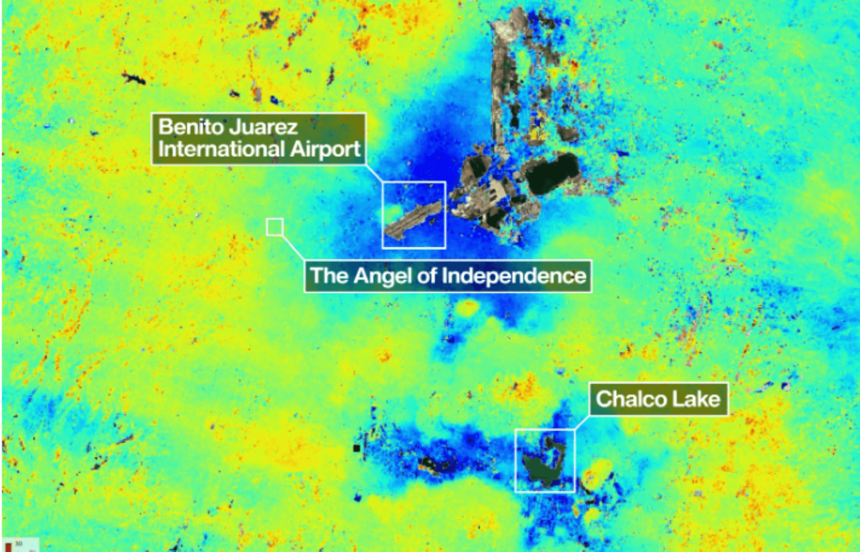
In a shocking revelation, NASA's new satellite technology has confirmed that Mexico City is one of the fastest sinking cities globally. The NASA-ISRO Synthetic Aperture Radar (NISAR) satellite has documented subsidence rates exceeding 2 centimeters per month in various areas of the metropolis, putting the city’s infrastructure—especially the Metro—at severe risk.
The Technology Behind the Findings
NISAR, designed by NASA in collaboration with the Indian Space Research Organization, began operations in July 2025. This sophisticated satellite employs advanced sensors to track surface changes in near real-time, even overcoming obstacles such as cloud cover. Preliminary measurements gathered from October 2025 to January 2026 have exposed severe subsurface shifts, leading researchers to mark areas of significant sinking in dark blue on their maps.
Craig Ferguson, deputy director of the project, emphasized the credibility of the findings: "Images like this confirm that the NISAR measurements are in line with expectations."
Causes of Subsidence
Mexico City, built on the ancient lake bed of Lake Texcoco, faces ongoing challenges as over a century of intense groundwater extraction combines with the immense weight of urbanization. The result is the compaction of the ground beneath the city, a phenomenon documented as early as 1925 by engineer Roberto Gayol. According to NASA, some neighborhoods are sinking at rates near 35 centimeters each year, leading to serious damage to critical infrastructure such as the city's expansive Metro system, which serves millions of residents each day.
Differential Subsidence: A Growing Concern
Recent research by Dario Solano-Rojas, a remote-sensing specialist at the National Autonomous University of Mexico, underscores the unpredictable nature of the subsidence. His study analyzed elevation changes from 2011 to 2020, revealing that sinking rates vary dramatically across the city. Some areas are affected by rates of up to 50 centimeters annually, while others experience negligible subsidence. This variation has serious implications for infrastructure stability, as differential subsidence occurs when sections of streets or buildings sink unevenly, leading to potential structural failures.
The Need for Continuous Monitoring
NASA's findings highlight the urgency of addressing these subsidence issues. The agency warns that even small, seemingly insignificant ground shifts can accumulate over time, resulting in cracks and ruptures in roads, buildings, and utility lines. "Accurately and continuously monitoring these terrain variations is fundamental for developing public policies and mitigation strategies," said Ferguson.
Conclusion: A Technological Solution
NISAR stands poised to play a pivotal role in this ongoing crisis. With its unique abilities to monitor the Earth’s surface with precision, NASA asserts that the satellite will lead to new discoveries and insights regarding subsidence not only in Mexico City but globally. David Bekaert, project manager at the Flemish Institute for Research in Technology, stated, "Mexico City is a well-known hot spot when it comes to subsidence. We’re going to see an influx of new discoveries from all over the world."
As the data continues to unfold, the focus must shift towards sustainable management and policy development to mitigate the risks posed by this geological phenomenon.
Popular news
Tokyo erupted in joy as fans celebrated Japan's 4-0 World Cup win against Tunisia at Shibuya Crossing, marking a momentous occasion in soccer.


Subscribe to
our news
Get the most important updates and top stories in your inbox.
