




 Technology29 Jul 2026
NASA’s New 3D Model Reveals Earth’s Uneven Gravitational Field
NASA's latest 3D model showcases Earth's uneven gravitational field, crucial for tracking ice loss and monitoring drought conditions worldwide.
NASA’s Innovative 3D Model
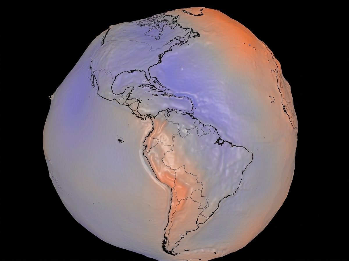
NASA has unveiled a remarkable new 3D model that reveals the irregularities of Earth’s gravitational field. This lumpy model is not merely a visual curiosity; it is a crucial tool in understanding our planet's dynamic environment, particularly in the context of climate change.
Understanding the Geoid Model
The newly released geoid model depicts Earth’s surface as a pronouncedly uneven landscape, exaggerated to illustrate variations in gravitational pull. These discrepancies arise from the uneven distribution of mass within the planet. If a global ocean were shaped purely by Earth's gravity and rotation, it would follow this lumpy profile. The visualization’s heights have been multiplied by a factor of 10,000, allowing for easier scrutiny of the gravitational variations.
The data used in this model comes from a comprehensive dataset accumulated over 15 years, encompassing over one billion observations from various satellites. Among these are missions conducted by NASA and the European Space Agency, which continuously monitor the gravitational field of the planet.
Implications for Climate Research
Impact on Ice Loss and Sea-Level Rise
One of the significant applications of this model is in tracking ice loss in polar regions. According to NASA’s Gravity Recovery and Climate Experiment (GRACE) satellites, Antarctica is losing approximately 135 gigatons of ice annually, while Greenland is even more impacted, with a loss of about 264 gigatons per year. Understanding these ice dynamics is critical for modeling future sea-level rise, as melting ice contributes directly to ocean levels and coastal flood risks.
Monitoring Groundwater and Drought Conditions
Additionally, the insights gained from this geoid model play a vital role in assessing global groundwater depletion and identifying drought conditions. GRACE data has revealed significant groundwater loss in areas like the western United States. This information is invaluable for water management, especially in regions grappling with ongoing drought conditions exacerbated by climate change.
An analysis from the University of Nebraska indicates that current soil moisture and groundwater levels in specific areas are nearing record lows, hinting at potential crises for local agriculture and water supplies.
Conclusion: A Tool for the Future
Through the adoption of this 3D model, NASA not only enriches our understanding of Earth’s shaping forces but also enhances our capability to respond to imminent climate challenges. As droughts increase and ice melt accelerates, this model provides crucial data that informs scientists and policy-makers alike on the urgent issues affecting our planet's future.
Popular news
A small plane crash while touring the Nazca Lines in Peru has resulted in 13 fatalities, including tourists and crew.




Subscribe to
our news
Get the most important updates and top stories in your inbox.